Rapid Ingestion & Fusion
Our proprietary AI/ML model, Or-Eng, processes raw images to identify object streaks and determine the trajectory through a comprehensive analytical pipeline.
LOCUS
High-precision RSO tracking & orbit propagation in real-time.

Track with confidence
Identify, track, record, and predict the orbital trajectory of resident space objects with unmatched precision and speed. Leverage the power of AIRA to get high-confidence state vectors, orbit propagations, and ephemerides that exceed traditional systems.

Track objects up to 8x per day vs. the industry's average of 0.5-1x.

Orbit predictions 40% more accurate than traditional systems with a < 50m positional error.

Detect objects as small as 3cm, tracking 20x more objects.

Data generated within just 5 minutes vs. the 20-30 minutes industry's average.

Fuse ground and space-based inputs for enhanced reliability.

Works with native sensors alongside external datasets to provide global coverage.
Our proprietary AI/ML model, Or-Eng, processes raw images to identify object streaks and determine the trajectory through a comprehensive analytical pipeline.
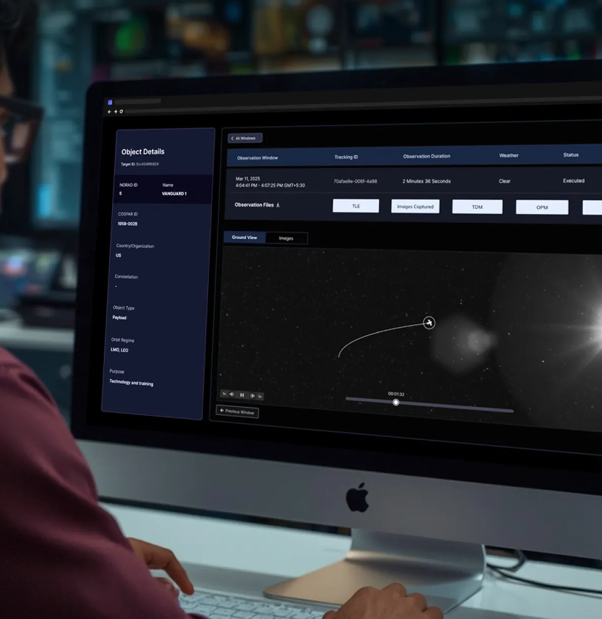
Data delivered as custom on-demand reports, or an API, or through a secure air-gapped SDK.
Seamlessly integrates into your Common Operating Picture (COP), mission planning platforms, or any custom data dashboards.
This whitepaper explores Digantara's robust pipeline for Initial Orbit Determination (IOD), Orbit Propagation (OP), and ephemeris generation. Central to these capabilities is our proprietary tool, OrEng, which plays a critical role in accurately identifying, tracking, and predicting Resident Space Objects (RSOs) in orbit. The whitepaper also presents a case study conducted at the company to assess the precision and accuracy of OrEng. For this study, the satellite Sentinel-3A (NORAD ID: 41335) was selected. The outcomes from OrEng, including state estimates and covariance, were compared with truth datasets obtained from the International Laser Ranging Service (ILRS).
This whitepaper explores how variations in neutral density, driven by space weather, impact the orbit prediction of Resident Space Objects (RSOs) in Low-Earth Orbit (LEO). It evaluates the accuracy of Digantara’s proprietary orbit propagator, OrEng, through a testing framework described in the paper. Four atmospheric neutral density models - NRLMSISE-00, NRLMSIS2.0, JB2008, and WAM-IPE - were employed to assess OrEng's performance across a spectrum of Space Weather events.
One of the primary challenges in sustainable Low Earth Orbit (LEO) satellite operations is the accurate forecasting of thermospheric neutral densities, which exhibit significant variability with the solar cycle and during geomagnetic storms. Extreme space weather events, such as the Gannon storm of May 2024, can severely destabilize satellite orbits and potentially cause premature re-entry. Traditional forecasting approaches face inherent trade-offs: empirical models offer computational efficiency but limited accuracy, while physics-based models provide higher accuracy at the cost of computational intensity. This whitepaper describes Digantara’s proprietary Space Weather (SWx) solution, a novel AI-driven methodology that leverages machine learning techniques to identify complex relationships between space weather drivers and thermospheric densities. Digantara’s Thermospheric Density Forecasting Model utilizes a comprehensive training dataset spanning 24 years of density measurements derived from actual satellite observations, supplemented with synthetic data to enhance model robustness and coverage. The report presents the results of a testing framework performed at the company to assess the accuracy of the Thermospheric Density Forecasting Model.