Secure Delivery
Data delivered as custom on-demand reports, or an API, or through a secure air-gapped SDK.
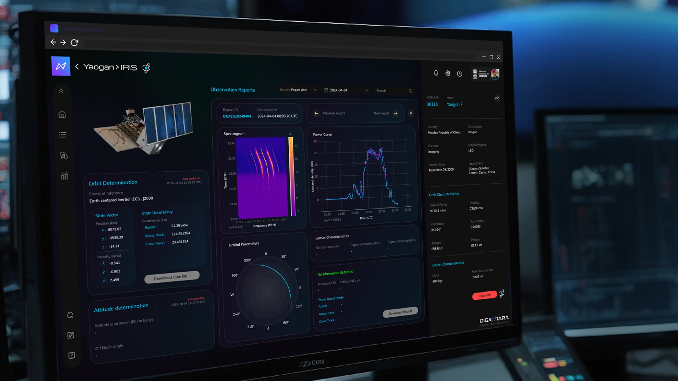
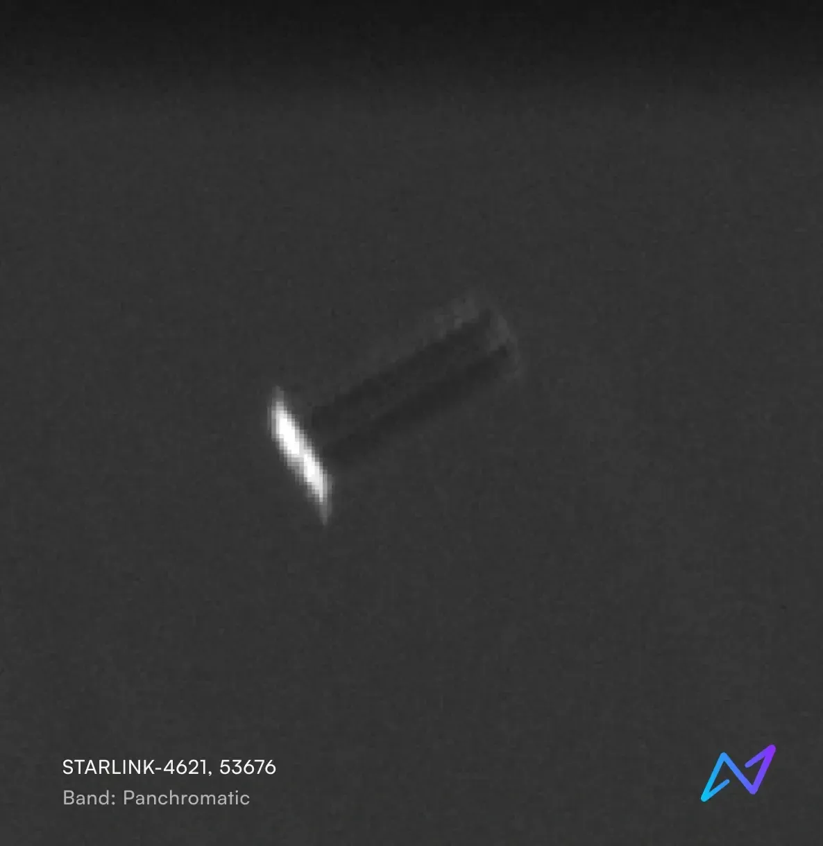
IRIS
Persistent non-earth imaging and RSO characterisation.
Space intelligence, made visible
IRIS provides high-resolution non-Earth imaging (NEI) and satellite RF signature mapping using advanced space-based sensors. Engineered to identify, characterise, and monitor the behaviour of space objects, this platform leverages precise and prompt detailing to give clearer insights even in low-light conditions.

Large-format sensors and fast, low-distortion lenses capture fine-grain detail.

Supports imaging even in low-light and complex orbital conditions.

Frequent observations for persistent tracking and time-based analysis.

RF sensing integrated with optics for more reliable and robust data points.

Onboard processing ensures low-latency object detection and data generation.
Data delivered as custom on-demand reports, or an API, or through a secure air-gapped SDK.
Seamlessly integrates into your Common Operating Picture (COP), mission planning platforms, or any custom data dashboards.
Supports real-time tasking and automated backend ingestion to deliver timely, actionable intel when you it.
The Pattern of Life (PoL) characterization of a satellite in Low Earth Orbit (LEO) is an intricate process demanding high fidelity data and robust data processing techniques. The solution to this complicated problem demands a methodology based on multiple perspectives and the ability to process, synthesize and correlate data from multiple sources of varying fidelity. Towards this objective, the current research proposes a dynamic and robust methodology to precisely characterize and synthesize PoL of satellites based on a multi-perspective multi-modal analysis, involving many aspects of a Space Domain Awareness (SDA) technological chain.
This whitepaper explores Digantara's robust pipeline for Initial Orbit Determination (IOD), Orbit Propagation (OP), and ephemeris generation. Central to these capabilities is our proprietary tool, OrEng, which plays a critical role in accurately identifying, tracking, and predicting Resident Space Objects (RSOs) in orbit. The whitepaper also presents a case study conducted at the company to assess the precision and accuracy of OrEng. For this study, the satellite Sentinel-3A (NORAD ID: 41335) was selected. The outcomes from OrEng, including state estimates and covariance, were compared with truth datasets obtained from the International Laser Ranging Service (ILRS).
One of the primary challenges in sustainable Low Earth Orbit (LEO) satellite operations is the accurate forecasting of thermospheric neutral densities, which exhibit significant variability with the solar cycle and during geomagnetic storms. Extreme space weather events, such as the Gannon storm of May 2024, can severely destabilize satellite orbits and potentially cause premature re-entry. Traditional forecasting approaches face inherent trade-offs: empirical models offer computational efficiency but limited accuracy, while physics-based models provide higher accuracy at the cost of computational intensity. This whitepaper describes Digantara’s proprietary Space Weather (SWx) solution, a novel AI-driven methodology that leverages machine learning techniques to identify complex relationships between space weather drivers and thermospheric densities. Digantara’s Thermospheric Density Forecasting Model utilizes a comprehensive training dataset spanning 24 years of density measurements derived from actual satellite observations, supplemented with synthetic data to enhance model robustness and coverage. The report presents the results of a testing framework performed at the company to assess the accuracy of the Thermospheric Density Forecasting Model.